|
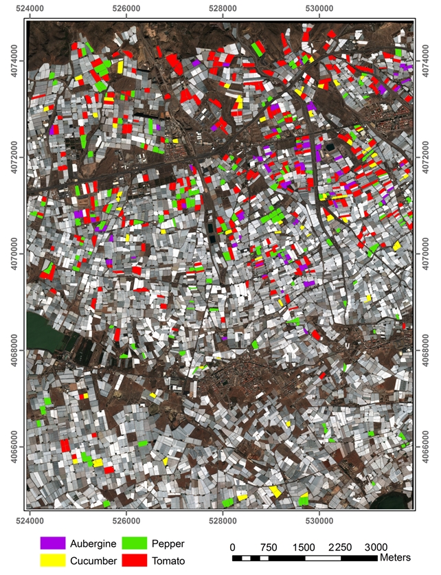
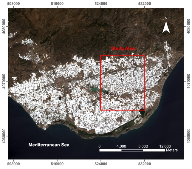
The practice of under plastic agriculture has had a great development in Spain, especially in Almeria, during the past 60 years, assuming a key economic driver in the area. In recent times, this productive sector is being affected by an unstable and changing geopolitical situation of the markets. In this regard, facts like the entry into force of the new agricultural agreement between the European Union (EU) and The Kingdom of Morocco adopted in 2012, or the Russian veto of horticultural products from UE in August, 2014, are causing important changes in the market prices of products grown in greenhouses, which significantly affect farmers and agribusiness. In order to alleviate these changes in market prices, each agricultural cooperative in Almeria is already making a planning acreage that their partners must dedicate to each product. However, a more globalized planning of horticultural productions would be desirable. Certainly, the possibility of knowing the crops are being grown under greenhouse in an agricultural campaign, both at our local productive sector and at our direct competitors, would help decision making and avoid having to destroy tons of horticultural products to keep prices. In recent years and in the framework of the National Research Plan Project referenced as CTM2010-16573 (http://www.ual.es/Proyectos/GEOEYE1WV2/index.htm), the capabilities of commercial very high resolution (VHR) satellite images to generate highly accurate georeferenced products such as orthophotos, digital surface models (DSMs) or land cover maps by using object based image analysis (OBIA) approaches have been demonstrated. More recently, the results attained from the project AGL2014-56017-R (https://w3.ual.es/Proyectos/GreenhouseSat/) have shown the possibility of improving, not only the classification of greenhouses by using OBIA techniques and time-series of satellite imagery but also the horticultural crops that are growing under plastic coverings. To date, an Overall Accuracy value ranging from 75% to 80% has been achieved in the classification of autumn and spring crops in Almería, being melon, watermelon, pepper and tomato the crops that showed better results. Against this background, the overall objective of this project in the field of remote sensing is to develop an object-based image analysis (OBIA) methodology to map and classify, exclusively using multi-temporal satellite optical images (WorldView-3, Deimos-2, Landsat 8 and Sentinel-2), horticultural crops grown in greenhouses. In order to study the possible for methodology transfer between greenhouses areas anywhere in the world, in this project we have added three new study areas (Agadir, Morocco; Antalya, Turkey; Bari, Italy) to the existing one located in the sea of plastic (Almería).
|


|
Abstract Project Sentinel-GH: Mapping Greenhouses and Identification of Protected Horticultural Crops Through Object-based Image Analysis and Satellite Imagery Time Series |
|
Proyecto I+D+i RETOS Estatal - RTI2018-095403-B-I00 “MAPEADO DE INVERNADEROS E IDENTIFICACIÓN DE CULTIVOS HORTÍCOLAS PROTEGIDOS MEDIANTE ANÁLISIS DE IMAGEN BASADA EN OBJETOS Y SERIES TEMPORALES DE IMÁGENES DE SATÉLITE ” |


|
Manuel Ángel Aguilar Torres Investigador Principal Full Professor
Teléfono: +34 950 015997 Fax: +34 950 015491 Correo: maguilar@ual.es |
|
Información de contacto: |


